Hiking the Presidential Traverse Trail in New Hampshire’s White Mountain National Forest is a milestone for numerous hiking enthusiasts. This journey marked my first solo multi-day hiking experience and remains one of the most challenging trails I have encountered.
The path to writing this piece was not easy, largely due to the formidable challenges I faced during the hike. However, I will focus on the trail itself and its logistics before delving into my personal account.
What is the Presidential Traverse Trail?
The Presidential Range, situated within the White Mountains of New Hampshire, features the tallest peaks in the region, including Mount Washington, the highest of them all. This 19-mile path encompasses 13 mountains, with 9 exceeding 4,000 feet in elevation, necessitating considerable elevation gain.
What mountains make up the Presidential Range?
- Mount Madison (5,367 ft)
- Mount Adams (5,774 ft)
- Mount Clay (5,533 ft)
- Mount Eisenhower (4,780 ft)
- Mount Franklin (5,003 ft)
- Mount Jackson (4,052 ft)
- Mount Jefferson (5,712 ft)
- Mount Monroe (5,384 ft)
- Mount Pierce (4,310 ft)
- Mount Quincy Adams (5,774 ft)
- Mount Sam Adams (5,774 ft)
- Mount Washington (6,288 ft)
- Mount Webster (3,911 ft)
How long does it take to hike the Presidential Traverse Trail?
This trek can be undertaken in various ways. Some individuals have completed the 19-mile route in one day, while others, including myself, prefer to do it in two days. The majority opt for a three-day experience, allowing for a more manageable pace and ample time to enjoy the scenery.
For those tackling the trail in less than three days, decisions regarding which summits to forgo become essential due to the loop trails necessitated for each peak. Time constraints may force hikers into hiking after dark, making an early start imperative.
How hard is the Presidential Traverse Trail?
This trail presents significant challenges. Many recommend starting at the Appalachia trailhead, ascending via the Valley Way trail heading south to preserve energy for the trail’s more arduous sections. The rocky terrain demands careful navigation, as an ankle injury could complicate your descent.
It is critical to monitor weather conditions prior to embarking, as adverse weather on the mountains can pose serious risks due to some of the highest wind speeds recorded in the U.S.
Several climbers noted the trial’s difficulty prior to my journey. I generally consider myself fit, as I engage in regular running and gym workouts. Yet, there were moments during this trek when I wanted to quit due to the strenuous nature of the trail. My initial realization of the challenge ahead manifested when I had to decide to skip Mount Madison’s summit to reach my hut on time, inadvertently choosing the most difficult route possible.
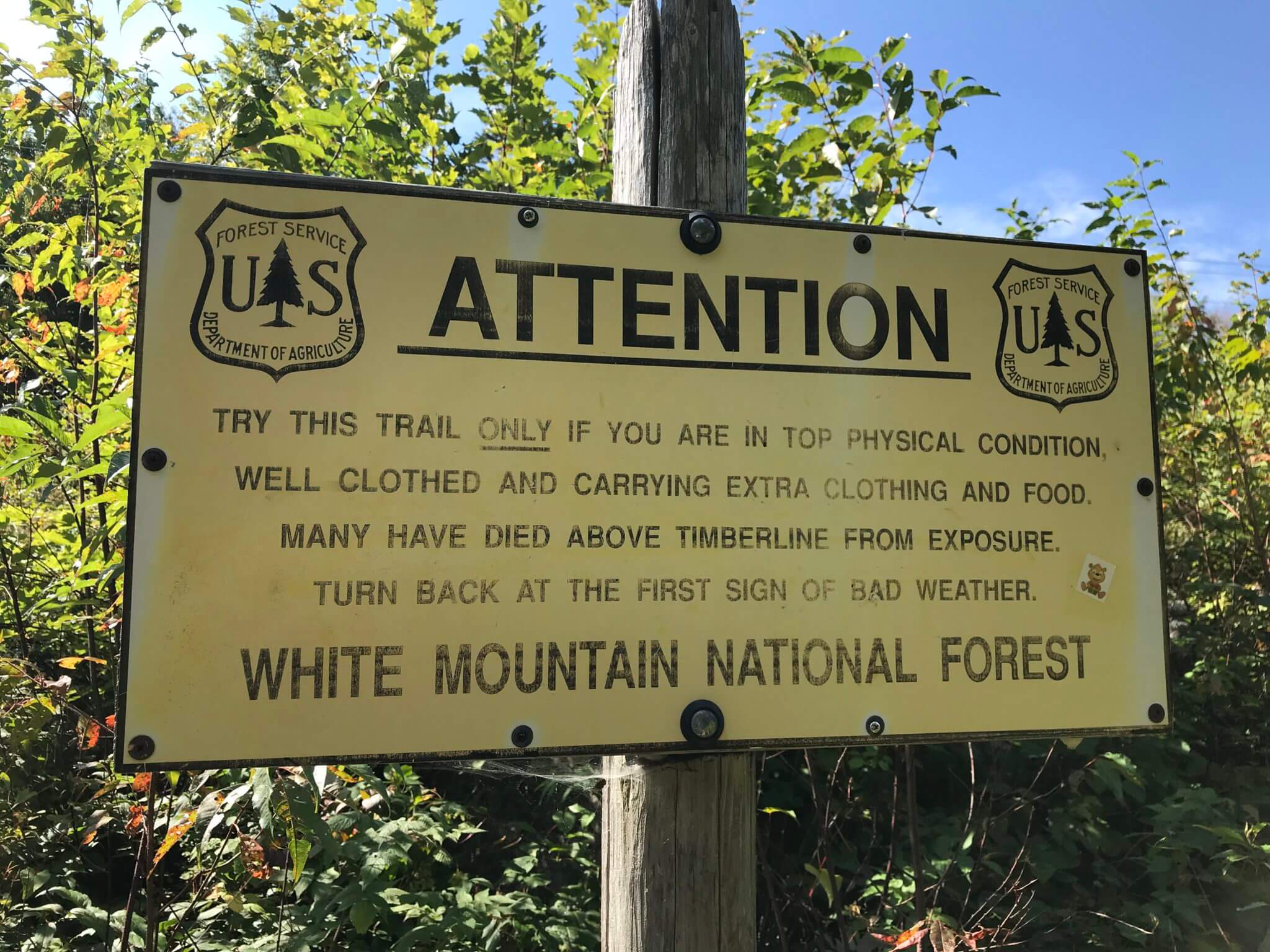
The warning sign at the beginning of the Valley Way trail accurately reflects the trail’s difficulty. The first half is predominantly rocky. This challenging terrain significantly slows progress and strains your feet. For me, the rocks were the most formidable obstacle.
If the trail were merely steep without the rocky challenges, it would have felt more manageable. However, the combination of steepness and rocky bouldering proved exhausting. I enjoy climbing rocks, yet it quickly became monotonous.
The second half of the trail, from the Lake of the Clouds Hut to the Mizpah Hut, is notably easier. This section sees various day hikers and trail runners, in stark contrast to the sparse traffic on the Valley Way trail to Lake of the Clouds Hut.
How to Prepare for the Presidential Traverse
Ensure adequate food, water, and clothing layers to protect against unexpected overnight conditions on the trail. For a comprehensive guide, refer to how to prepare for the Presidential Traverse Trail.
Huts and Camps
Appalachian Mountain Club huts or consider camping options along the way, ensuring you camp below the tree line to protect sensitive plant life at higher elevations.

The availability of huts enhances the experience. You carry less food, receive two meals during your stay, get updated weather forecasts, and meet various individuals.
The Trail – My Story
Day 1
I embarked on this hike over two days. Initially, I aimed for a one-day challenge, driven by a desire to test my limits physically and mentally. However, I settled for two days mainly to accommodate a night at the Lake of the Clouds Hut, a coveted experience among many hikers.
Arriving in Gorham, New Hampshire, the night before my hike, I felt excite and apprehensive while preparing my gear the next morning. My anxiety stemmed from concerns about parking and reaching my shuttle on time. I parked beside the Highland Center at Crawford Notch, where the AMC shuttle transports hikers to the trailhead for about $25. The earliest shuttle leaves at 9 AM, landing hikers at the Valley Way trailhead by 10:05 AM, which I now recognize as my first error.
On the shuttle, I connected with fellow hikers, some of whom I would encounter again on the trail. However, once on the path, individual pacing caused the group to disperse.

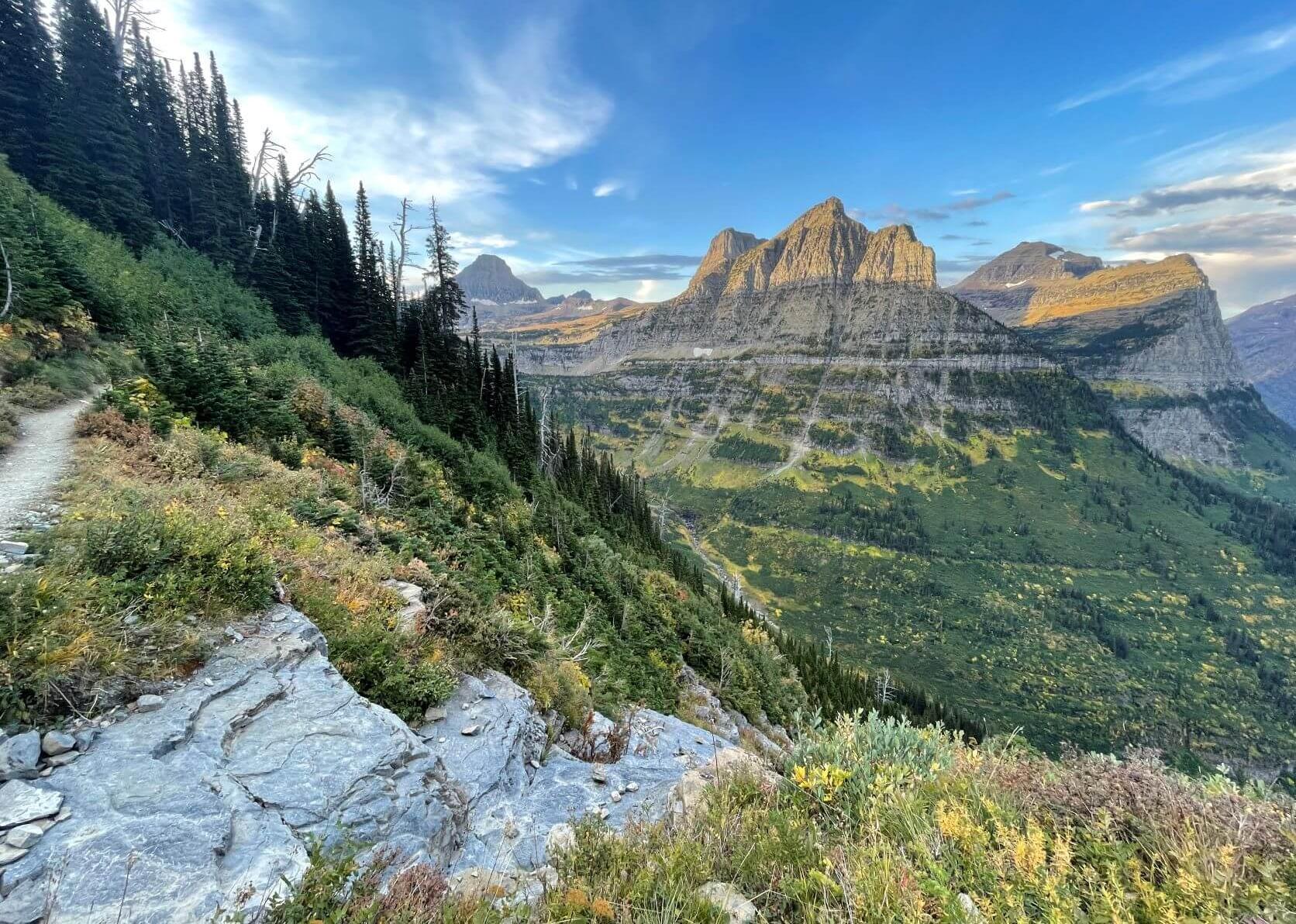
Your first day begins on the Valley Way trail, a steep 3 to 3.5-mile ascent to 4,500 ft. Initially, the trail winds through a pleasant forest environment. As you ascend and the air thin out, the incline intensifies, slowing your pace. The Mount Madison Hut acts as an opportunity for a break, offering lemonade and coffee cake while taking in the breathtaking vistas.
Upon reaching higher elevations, I faced a difficult choice: I had to skip Mount Madison’s summit since it diverged from my intended route. After the hut, multiple trails branch off; unfortunately, I mistakenly took the Spring Lake trail, believing I was continuing on the Appalachian Trail. This error added more elevation as I clambered hand over hand up Mount Adams through a boulder field, accompanied by mounting frustration.


Despite my mental struggles, I eventually summited Mount Adams and continued toward Thunderstorm Junction, where rocky terrain prevailed. As I glimpsed Mount Washington, shrouded in clouds, I felt deceived by the illusion of proximity to the hut.

The winds intensified as I neared Mount Washington, bringing a chill that necessitated a pause to don a hat and mittens. Consuming some slightly frozen granola bars provided minor comfort amid the growing discomfort from my aching feet and shoulders.
Although quitting crossed my mind numerous times, I persevered by focusing on placing one foot in front of the other, with no alternative plan in sight.

An unsettling mood pervaded my thoughts; I grappled with feelings of inadequacy compared to experienced AT thru-hikers, but resolved to adhere to my mantra: “everyone has to hike their own hike, regardless of how it appears.”
Arriving at Mount Washington, I anticipated enjoying a refreshing Snapple before heading to the hut, yet I soon realized dinner was becoming less feasible.
As I approached the summit, harsh winds and thick clouds obscured the view. Upon reaching the trail junction to either the Lake of the Clouds hut or the summit, I opted for the hut.
Exhausted and almost at my limit, I could see the hut from a distance, but the harsh conditions delayed my desire to use my headlamp, preferring to avoid taking off my pack.
Vividly imagining spending the night on the mountainside, I pushed aside my despair and continued persevering, determined to reach the hut.
At 9 PM, enveloped in darkness, I arrived at the hut, greeted by people and a crew offering food and accommodations.
Elated yet fatigued, I had completed my trek. I hiked my own journey without concern for others’ opinions on my chosen summits. In sheer need of nourishment and rest, I looked forward to embarking on the second leg of my adventure with renewed optimism.
Reflecting on my achievements, I take pride in conquering what I could, despite not summiting every peak. Completing the Presidential Traverse Trail is an accomplishment no one can diminish.
Perhaps one day, I will return to savor the moment and summit every peak, free from the pressures of time and competition.
Day 2
Following a restful night filled with food and camaraderie, I felt rejuvenated for the next segment of my trek along the Presidential Traverse Trail.
Multiple blogs suggest that traversing from north to south allows hikers to tackle the most difficult segments of the trail with fresh energy.
I can attest that the northern section presents significant challenges. Departing from the Lake of the Clouds Hut (elevation: 5,012 ft) on Day 2 filled me with optimism. Having meticulously reviewed my map, I set off with purpose.
However, I inadvertently veered off course initially, disoriented by a hiker’s insight confirming my route led back to Mount Washington.
Fortunately, I had not traversed far before rectifying my direction.
Upon finding the correct trail, progress felt easier as I took the loop trail to ascend Mount Monroe (elevation: 5,372 ft), which reinstated my confidence.
The summit of Mount Monroe offered stunning views, setting the stage for the most beautiful section of the Presidential Traverse Trail.

The second summit, Mount Eisenhower (elevation: 4,760 ft), follows Mount Monroe. As I ascended the steep switchbacks, the summit’s notable cairn welcomed me, accompanied by stunning vistas.
Surrounded by the lofty White Mountains, I pondered the grandeur they possess in winter’s snow.

The day presented excellent weather, with mild breezes and temperatures ranging from the upper 30s to low 40s. I could have leisurely lingered at the summits; my body was grateful for the rest.
The route from Eisenhower to Mount Pierce seems to span a longer distance, weaving in and out of the alpine zone. However, the distance from Monroe to Eisenhower matches that of Eisenhower to Pierce.
I encountered various day hikers and trail runners throughout this day; having experienced only multi-day hikers on the previous day, it was apparent how much easier this section is.
Nonetheless, this segment remains challenging; yet after my previous day’s trials, it felt refreshingly manageable.
The alpine zones were notably wetter, featuring manmade wooden trails. One final section leads to a junction: continuing down brings you to the Highland Center at Crawford Notch, while a short ascent leads to Mount Pierce’s summit (elevation: 4,312 ft). As a concluding peak, it felt somewhat anticlimactic compared to the majestic views from Monroe and Eisenhower.
From Pierce, you may either proceed to Mizpah Hut (0.8 miles away) and subsequently summit Mount Jackson (1.6 miles from hut to summit) or take a side trail (Mizpah cutoff) joining the Crawford Path leading to the Highland Center.
Based on my conversation with the Lake of the Clouds Hut crew, I opted to summit Pierce before backtracking to the crossroads and following the Crawford Path out. The crew lauded this trail’s beauty as a wonderful conclusion to my hike, while expressing Mount Jackson as the hardest hike they had experienced.

Upon reaching Mount Pierce’s summit, my feet and shoulders had reached their limits. It was time to meticulously make my way off the trail. Others opted for the Mizpah detour for snacks and refreshments, but my hike had concluded.
The descent felt interminable as I struggled to the trail’s end, lamenting the relentless rocks reappearing. My feet and shoulders throbbed as I navigated the route through the forest’s cool embrace.
Frequent breaks became necessary as they offered manageable intervals to continue. The trail’s exceptional beauty affirmed the crew’s suggestion, confirming it as a splendid choice, should your feet withstand the challenge.
Ultimately, the trail delivered me onto the road, and I slowly ambled to my awaiting vehicle. Exhausted yet triumphant, I had completed my journey.
Throughout my hike, I constantly reminded myself that each individual must hike their own hike. The pace does not matter; this is not a competition. No one would harbor disappointment regarding my performance. The path I chose was mine alone to navigate.
Concluding Thoughts
In retrospect, I take immense pride in my accomplishments. Yes, I missed a few summits due to my planning choices, and the three-day journey affords a richer experience. However, I am content with what I completed.
While I may not revisit this trek, the allure of a more relaxed three-day journey lingers in my thoughts. But for now, I can reflect with pride on my achievements—a testament to my resilience and strength.
For additional insights on planning your hike, you can refer to my guide on How to Prepare for the Presidential Traverse.